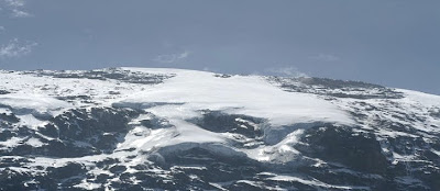
Mt. Kilimanjaro, Africa's highest peak and one of the continent's magnificent sights.
Composed of 3 extinct volcanoes:
1: Kibo = 5895 MASL
2: Mawenzi = 5149 MASL
3: Shira = 3962 MASL
Area of the park is 756 sq km.
Established as a park in 1973, and officially opened in 1977.
The park exists to preserve Mt. Kilimanjaro's outstanding scenic and geological features and its flora and fauna for the use of enjoyment and aesthetic values. For the future generation and for the generation yet to come. Enjoyment of the people and that is the aim of the forest to be reserved, as well as for the aesthetic values.
THE NAME: The Wachagga people, traditionally agriculturists of the area, claim they had no name for the mountain itself, just the peaks which they call kipoo and kimawenzi.
Most speculations assume the name comes from two root words kilima and njaro. Kilima comes from the kiswahili word for mountain, mlima. The addition of ki is puzzling because in kiswahili this is a diminutive and so mlima or kilima means small hill. It has been suggested that the use of the diminutive is a gesture of affection towards the huge mountain.
The njaro part of the name is much more confusing. It could come from a kichagga word for caravan, referring to the possibility that caravans used the mountain as a landmark. There is speculation that a word used on the coast, njaro was the name of a demon that caused cold. Presumably traders or porters used the name when they traveled inland or heard tales about a high cold mountain.
Another possibility is that the travelers asked the Maasai living on the plains what they called the mountain and the Maasai may answered that it was the source of water, using the word ngare which was corrupted to njare or njaro.
ROUTES UP THE MOUNTAIN:
1: MARANGU ROUTE:
DAY 1: Marangu to Mandara Hut
DAY 2: Mandara to Horombo Hut
DAY 3: Horombo Hut to Kibo Hut
DAY 4: Kibo Hut to Summit to Horombo Hut.
DAY 5: Horombo Hut to Marangu.
The schedule, trails and accommodation are all designed to allow the visitor time to acclimatize. An extra day at Horombo, Mawenzi, or Kibo Hut is recommended to allow even more time to get the altitude.
DISTANCES:
Marangu Gate to Mandara Hut = 3- 4 Hours
The Forest trail is slower.
Mandara Hut to Horombo Hut = 5-6 Hours.
Horombo Hut to Kibo Hut = 5-6 Hours.
Kibo Hut to Gillman's Point = 5-6 Hours.
Gillman's Point to Uhuru peak = 1-3 Hours.
2: MWEKA ROUTE:
This is the fastest and most direct and steepest route to the summit. Starts from Mweka College.
DISTANCE:
Mweka College to Mweka Huts: 6-8 Hours.
Mweka Huts to Barafu Huts: 6-8 Hours.
Barafu Huts to Kibo Rim = 6 Hours, one Hour more to Uhuru Peak.
3: UMBWE ROUTE:
This is a relatively short, steep. scenic route. It is better to descend it from Machame or Mweka routes than to climb it. From Moshi - Arusha road, drive north past Waruweru for 15 kms along Lyamungo road. You will cross Lonzo and Umbwe Rivers.
4: MACHAME ROUTE:
Probably the most beautiful route up Kilimanjaro, with a lovely gradual ascent through forest you emerge to see wide views of the Moorland on Shira plateau, Kibo and the Western Breach.
DISTANCES:
Machame Village to Park Gate = 2 hours.
Park Gate to Trailhead = 2 hours.
Trailhead to Machame Huts = 4 to 5 hours.
Machame Huts to shira Huts = 5 hours.


No comments:
Post a Comment